Introduction by John McGlone
As a navigator in the U.S. Navy, retiring after 21 years it took me over four years of regular and sometimes very intense seasons of study to answer enough questions for myself to come to the cosmological view of geocentricity and the flat earth domed model of our ‘earth’ that I would actually discuss and promote these things publicly.
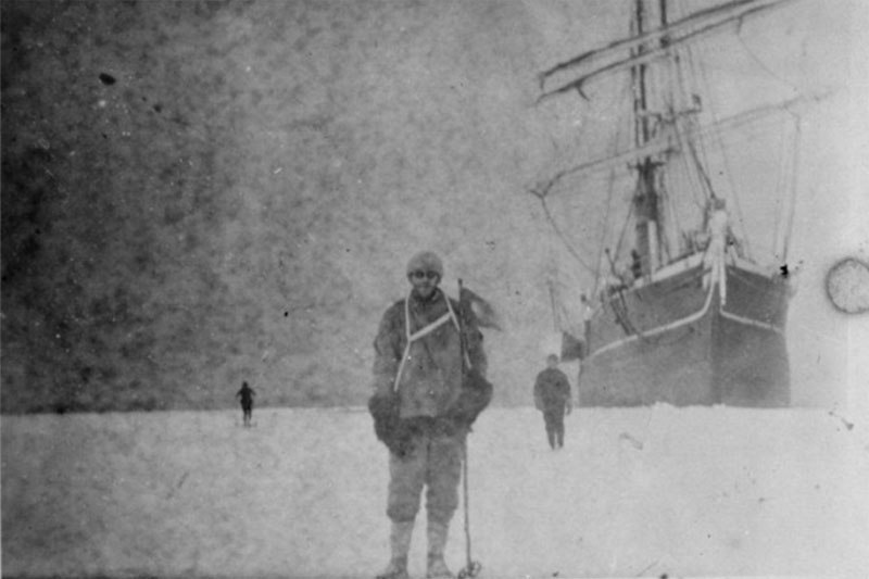
Ship Captains and First Mates have wrestled through hundreds of years of voyaging and the two worst areas to sail are the northern and southerly latitudes. Anything above or below the Arctic or Antarctic Circles were filled with horrifying stories of men and ship’s inexplicably and tragically lost. It is now my belief that God has topographically, environmentally, and naturally hindered the approaches to the ‘north pole’ or the icy edge of the ‘southern’ continent. Check the following reading I am currently studying for information about these relatively modern mariners struggles in the southerly latitudes especially.
excerpt by Edward Hendrie’s book, “The Greatest Lie on Earth”
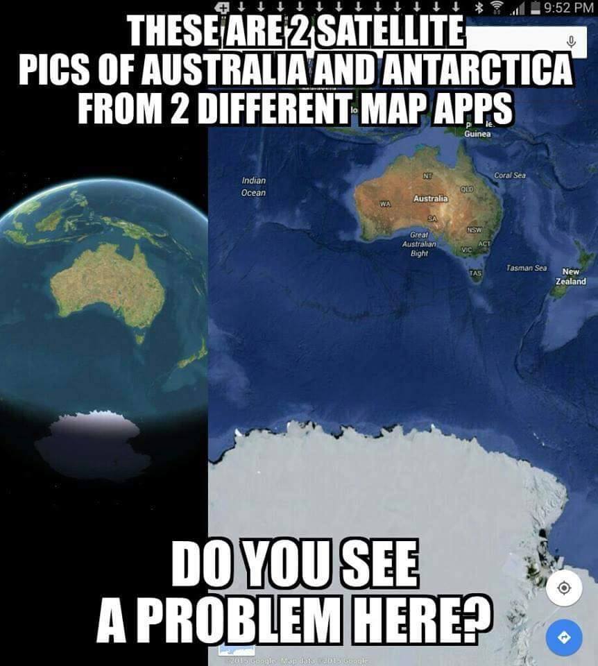
Obviously, the globe model presents the traveler with a significantly different configuration than does the flat earth model, particularly in the so-called “southern hemisphere.” The discrepancy between the reality of a flat earth and the myth of a south seas.
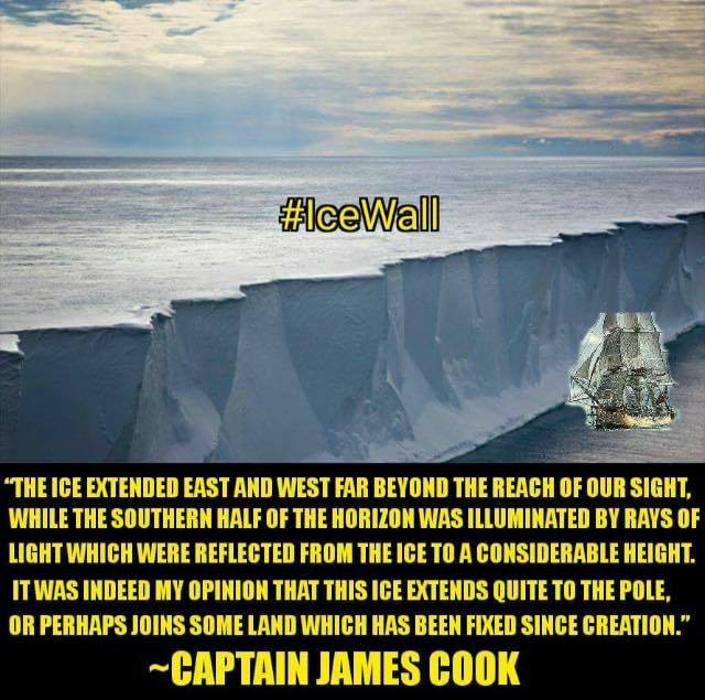
Samuel Rowbotham, in his book Zetetic Astronomy, explains the dangers of the false charts based upon a globe model: In the southern hemisphere, navigators to India have often fancied themselves east of the Cape when still west, and have been driven ashore on the African coast, which, according to their reckoning, lay behind them. This misfortune happened to a fine frigate, the Challenger, in 1845.405 How came Her Majesty’s Ship Conqueror, to be lost? How have so many other noble vessels, perfectly sound, perfectly manned, perfectly navigated, been wrecked in calm weather, not only in a dark night, or in a fog, but in broad daylight and sunshine–in the former case upon the coasts, in the latter, upon sunken rocks–from being ‘out of reckoning,’ under circumstances which until now, have baffled every satisfactory explanation.406 Rowbotham explains how the British ship Challenger completed the circuit of the southern region, indirectly, to be sure, circumnavigating Antarctica. The approximate circumference of Antarctica is supposed to be approximately 14,460 statute miles on the globular earth model. However, the Challenger spent three years and traversed nearly 69,000 miles. That is a distance that would have allowed the ship to circle Antarctica over 4 times if the earth were in fact a globe. The 69,000 mile long journey around the circumference of the earth that is Antarctica, however, is perfectly explained by a flat earth.
Rowbotham quotes from voyagers, who found that their charts, which used a globular earth model, almost always put them off course in the south seas. “We found ourselves every day from 12 to 16 miles by observation in advance of our reckoning.” Another southern seafarer stated: “By our observations at noon we found ourselves 58 miles to the eastward of our reckoning in two days.” The spherical earth charts did not account for the expanse of distance between the lines of longitude the further south one travels on a flat earth. Consequently, the mariners’ true position on the earth, determined by using celestial navigation and a chronometer, was found to be off by several degrees from the position on the chart that was plotted using dead reckoning. One mariner detailed the distance that the erroneous charts, which assumed a globular earth, put them off course in the south seas. February 11th, 1822, at noon, in latitude 65.53. S. our chronometers gave 44 miles more westing than the log in three days. On 22nd of April (1822), in latitude 54.16. S. our longitude by chronometers was 46.49, and by D.R. (dead reckoning)47°11´: On 2nd May (1822), at noon, in latitude 53.46. S., our longitude by chronometers was 59° 27´, and by D.R. 61° 6´. October 14th, in latitude 58.6, longitude by chronometers 62° 46´, by account 65° 24´. In latitude 59.7. S., longitude by chronometers was 63°28´, by account 66°42´. In latitude 61.49. S., longitude by chronometers was 61° 53´, by account 66° 38´.
The skippers of the ships in the south seas could only guess that the discrepancies between their dead reckoning plotted on their charts and their true positions, confirmed by precise chronometers and sextants, was due to the currents. Rowbotham explains, however, that currents could not possibly account for the navigation errors, because the errors in the navigation were manifested regardless of whether the ships were traveling east or west. The commander of the United States exploring expedition, Lieutenant Wilkes, in his narrative, says that in less than 18 hours he was 20 miles to the east of his reckoning in latitude 54° 20´ S. He gives other instances of the same phenomenon, and, in common with almost all other navigators and writers on the subject, attributes the differences between actual observation and theory to currents, the velocity of which, at latitude 57° 15´ S., amounted to 20 miles a day. The commanders of these various expeditions were, of course, with their education and beliefin the earth’s rotundity, unable to conceive of any other cause for the differences between log and chronometer results than the existence of currents. But one simple fact is entirely fatal to such an explanation, viz., that when the route taken is east or west the same results are experienced. The water of the southern region cannot be running in two opposite directions at the same time; and hence, although various local and variable currents have been noticed, they cannot be shown to be the cause of the discrepancies so generally observed in high southern latitudes between time and log results. The conclusion is one of necessity–is forced upon us by the sum of the evidence collected that the degrees of longitude in any given southern latitude are larger than the degrees in any latitude nearer to the northern centre; thus proving the already more than sufficiently demonstrated fact that the earth is a plane, having a northern centre, in relation to which degrees of latitude are are diverging lines, continually increasing in their distance from each other as they are prolonged towards the great glacial southern circumference.
Conclusions by Br. John McGlone
In closing: 1. Admiral Byrd’s adventures into the Antarctica revealed the immensity and impossibility of actually confirming the globe. 2. The forensic evidence of the edge of our world has forced the nations of the earth to an inclusive treaty that everyone has kept! 3. The old school mariners had the same problem modern ones do in higher latitudes especially the southerly 4. The actual distance to circle the ‘continent of Antarctica’, or more accurately circle the perimeter of the edge, must be greater than approximately 70.000 nautical miles. 5. Because I don’t believe we have even ventured close to where the heavenly firmament [dome] meets the edge of the terra firma we can’t really give an exact measure of the distance in point four. 6. God has set these limits upon mankind to point them to Himself. Topographic, extreme weather temperatures, pressures, storms, hardness of the firmaments, etc also prevent us from venturing beyond our terrestrial environ. 7. All of this is confirmed by natural and spiritual evidences in our own experiences, in Holy writ, and extrabiblical literature.
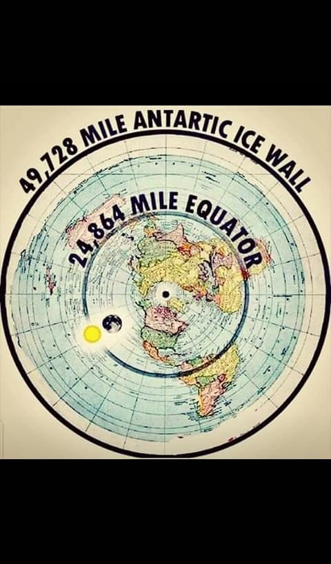
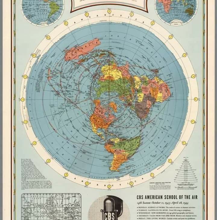
Finally, IF the edge of the FE = ~70,000 nautical miles / π or 3.14 = ~ 22,293 nm
This is very close to the calculated circumference of the ‘globe’ by the pythagorean theorum and is confirmed by actual distances from the center or ‘north’ pole and the edge of the antarctic continent or rim. From 90°N the north pole or center pole of the earth to the equator = 5400 nm from the equator to 90°S or the edge of the face of the earth = 5400 nm. So, 5400 nm X 4 quadrants = 21,600 nm. Stop the presses this must mean we live on a globe right? Wrong. The pi presumes a circle in our calculation but for global believers they presume a 3D globe. But, FE’rs don’t presume a pancake, but a structure as the Bible describes with foundations, pillars, the deep etc. If you go to google earth you will see how they can jump between 2D & 3D with the click of a button, let that sink in for a few minutes….